Ausseer Zinken


- Flatly
Interactive elevation profile
Create PDF
Tour-Details
Paths covering:
Der Gipfelsieg über den Ausseer Hausberg ist mit Anstrengung verbunden.
Technique: ***
Quality of experience: ******
Recommended season:
- June
- July
- August
- September
- October
Properties:
- Loop
- Scenic
- Summit route
Steile Anstiege erfordern Ausdauer, Kondition und Trittsicherheit. Eine herrliche Aussicht über das Ausseerland und das Innere Salzkammergut lässt alle Mühen vergessen. Nach Regenfällen ist der steile An- und Abstieg sehr rutschig! Abstieg Handlerstiege mit Seilsicherung versehen.
Directions:
Vom Bahnhof Bad Aussee gehen wir in westliche Richtung auf der Koppenstraße, queren den Bahnübergang, gehen die Straße aufwärts weiter und erreichen links einen Forstweg, von dem der markierte Alpin-Weg Nr. 695 über den Planer zum Gipfel des Zinken führt. Der rot-weiß-roten Markierung folgend erreichen wir den tiefen Planergraben. Ein schmaler Steig windet sich neben dem Graben steil durch den Hochwald bergan. In 1.000 m Höhe queren wir einen alten Steig, der von der westlich gelegenen Fidl Alm bis in das östlich gelegene Gebiet der Himmeleben beim Ödensee führt. Dieser Steig wurde einst als Verbindungsweg zwischen mehreren Jagdhütten angelegt. Heute ersetzen Forststraßen den Steig, weshalb er dem Verfall preisgegeben wurde.
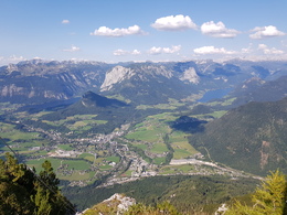
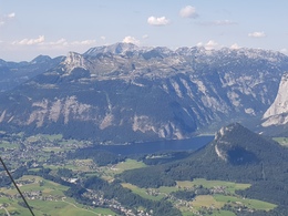
Von rechts kommt eine Forststraße herauf. Weiter geht es steil aufwärts durch den Wald. Der Weg wendet sich nach rechts, wird steiniger und bringt uns zur Waldgrenze in 1.500 m Höhe. Wir kommen zu einer Quelle, lassen den Hochwald hinter uns und wandern in Serpentinen den Graben hinauf. Auf steinigem Untergrund erreichen wir eine Schutthalde unterhalb des Eislochkogels (1.830 m). Nach einem weiteren, kurzen Anstieg bietet sich ein herrlicher Ausblick über das Ausseer Becken und den gegenüberliegenden Sarstein. Der steile Teil ist nun vorbei. Sanft ansteigend wandern wir am rechts gelegenen Feuerkogel vorbei. Alljährlich werden auf diesem Kogel die weithin sichtbaren Sonnwendfeuer entzündet.
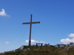
Die Markierung führt uns absteigend durch Latschenfelder in südliche Richtung weiter. Vom tiefsten Punkt des Wegs zweigt rechts der nicht markierte Almsteig zur Planeralm ab. Wir gehen jedoch links ansteigend zwischen Latschen weiter und erreichen bald darauf felsiges, grasbewachsenes Almgelände. Rechts kommt der Alpin-Weg Nr. 696 von der Handleralm herauf. Geradeaus weiter wandernd kommen wir zum mächtigen Gipfelkreuz am Zinken-Kogel in 1.854 m Höhe.
Das 8 m hohe Gipfelkreuz wurde von handwerklich geschickten Schülern des Polytechnischen Lehrgangs 2004/2005, der Hauptschule Bad Aussee, unter der Leitung ihres engagierten Lehrers Franz Amon gebaut und aufgestellt. Im Rahmen einer Bergmesse wurde es am 14. August 2005 eingeweiht. Ein herzliches Danke allen, die daran beteiligt waren! Es ist wahrlich ein Gott begnadeter Aussichtsplatz. Das gesamte Ausseerland zu Füßen, den Dachstein zum Greifen nahe, genießen wir die wohlverdiente prachtvolle Aussicht.
Der Abstieg führt uns zurück bis zur Wegkreuzung, der wir links auf dem Alpin-Weg Nr. 696 folgen. Er führt uns südwärts über einen Felssturz und abfallende Geländestufen ca. 200 Höhenmeter hinunter, wendet sich dann nach Osten und erreicht unterhalb des Zwicker Kogels nach ca. 1 km die Handleralm (1.649 m). Wir folgen der Markierung links über das Almgelände ansteigend zu einem Sattel hinauf. Der Weg führt uns kurz nach rechts und dann links absteigend hinunter in ein weites, felsiges Kar. Wir kommen zur steil hinunterführenden „Handlerstiege“, die mit einer Seilsicherung versehen ist. Vorbei an einer Quelle gehen wir abwärts über einen Waldrücken am rechts gelegenen Äußeren Hornkogel vorbei. In ca. 1.000 m kommen wir zu einer Forststraße, queren diese und setzen unseren Abstieg auf dem Alpin-Weg Nr. 696 talwärts fort. In Serpentinen absteigend queren wir nochmals eine Forststraße und erreichen nach ca. 1 km das Bahnhofsgelände und unseren Ausgangspunkt.
Safety guidelines:
Trittsicherheit, Schwindelfreiheit und Bergerfahrung.
Equipment:
Feste Bergschuhe, gute Wanderausrüstung, Regenschutz, Getränke und Proviant.
Additional information:
Alle Touren basieren auf unseren "Wanderführer Ausseerland - Salzkammergut" von Monika Gaiswinkler und dem Tourismusverband Ausseerland-Salzkammergut.
further information:
- Flatly
- Experience of nature
- Summer
- Autumn
Please get in touch for more information.
Pratergasse 388
8990 Bad Aussee
Phone +43 3622 54040 - 0
E-Mail info@ausseerland.at
Web www.ausseerland.at
Vis-à-vis users
1. The tours presented for hiking, walking, biking and road biking, mountain biking, motorbiking, horseback riding, climbing, cross-country skiing, and going on skiing and snowshoe tours etc. are to be considered non-paid tour recommendations and only serve as non-binding information. We have no intention of concluding a contract with the users of this website. The utilisation of the data does not lead to the establishment of a contract with us.
The data may only be used for private use; any commercial use is prohibited. In particular, it is not permissible to offer the data on commercially run websites, file-sharing platforms etc. or to use it to develop commercial products. Downloading data does not imply that users are granted rights to the data concerned.
The tour recommendations posted were created with utmost care; nevertheless, we assume no liability for the correctness and completeness of the information.
We point out that neither the tour recommendations included on this website nor the associated data and information were posted by us, but rather by third parties (Art. 16 Austrian E-Commerce Act). We have no influence on whether the details provided (e.g. distance, level of difficulty, change in altitude, description etc.) are authentic, correct and complete. We do not review these third-party contents. For this reason, we assume no liability for the authenticity, correctness and completeness of the information.
Construction-related measures or other influences (e.g. landslides and similar occurrences) can lead to temporary or permanent changes in a route (e.g. loss of a bridge and similar occurrences). Such occurrences can lead to part of the route or the entire route becoming impassable.
The use of the data as well as undertaking (riding, walking, taking etc.) the recommended tours or using the network of paths occurs at users’ own risk and on their authority. In particular, users themselves are responsible for the choice of route, outdoor orientation, adherence to traffic rules, supplies and equipment for tours listed in Point 1 (e.g. bicycle etc.), wearing a helmet, estimating their own fitness, recognising dangers and maintaining an appropriate velocity. We exclude ourselves from any liability whatsoever for damages, in particular accidents, that occur whilst taking part in the recommended tours.
2.Some of the tours lead over roads with normal traffic conditions. Please observe that there is an increased risk which can be avoided by means of appropriate attention and proper estimation and implementation of one’s own abilities. For this reason, please travel a route that is unfamiliar to you slowly and with special care. Pay constant attention to potential dangers and always observe traffic. Do not leave the routes featured in descriptions.
The potential use of private roads, in particular forestry roads and agricultural transport roads, can be subject to legal restrictions, which must be observed and adhered to.
The normal traffic rules apply. Each user (e.g. biker, motorbiker) is responsible for adhering to these rules and maintaining his/her bike/vehicle and its equipment (lights, brakes etc.) in good working order. Each user is also responsible for ensuring that he/she rides at a velocity that is appropriate for the conditions and his/her skill level and for maintaining sufficient distance to the rider in front. We explicitly recommend adjusting velocity to correspond to the respective field of vision, wearing a helmet, using reflective clothing (or similar) and employing bicycle lights in line with regulations.
3.Each tour requires good physical fitness as well as detailed planning. We explicitly recommend only taking the tours in the case of optimal healthiness.
We recommend that you conclude an accident and liability insurance policy. Use an onboard computer that displays the respective kilometres travelled per day and is calibrated for the front wheel.
4.Special for mountain bikers – Fair-play rules:
Mountain biking is one of the most wonderful outdoor leisure-time activities. Whilst biking or on a mountain biking tour, mountains and lakes, meadows and cabins are re-discovered in new ways. A couple of rules for fair play in the forest help to avoid conflicts whilst mountain biking.
a.Pedestrians have the right of way: We are accommodating and friendly to pedestrians and hikers. Upon encountering these fellow travellers, we alert them by using the bicycle bell and slowly overtake them. We avoid paths with heavy pedestrian traffic altogether. Take nature into account: We do not leave refuse behind.
b.The braking distance should be half of the total distance visible: We ride at a controlled pace, are ready to brake and maintain a braking distance half as long as the total distance visible, especially in curves, because we always have to count on obstacles on the path. Damage to the path, stones, branches, wood piles, grazing livestock, cattle grids, barriers, tractor-type forestry machines and authorised vehicles pose dangers that we need to be ready for.
c.Don’t drink and drive!: Do not drink alcohol when mountain biking. Take care at stop-off points (dealing with bike racks, dirty shoes or clothing).
It is obligatory to provide first aid!
d.Marked routes, closed paths and blockades: Keep to the marked routes, observe the blockades and accept that these roads are primarily for agricultural and forestry use!
Blockades can often not be avoided and are in your own interest. Biking beyond the intended path and outside of opening times is punishable and turns us into illegal bikers.
e.We are guests in the forest and behave accordingly, including vis-à-vis forestry and hunting staff. Whilst mountain biking, mobile telephones and music players are forbidden! Biking requires your full attention.
f.Avoid unnecessary noise. Out of consideration to the animals living in the wild, we only bike during full daylight. As a principle, we always wear our helmet (even when riding uphill)! Don’t forget emergency supplies: We always have a repair set and bandages along.
g.Don’t overestimate your skills: We should not overdo it when it comes to biking technique and physical fitness. Take the level of difficulty posed by the route into consideration and make a precise estimate of your experience and skills as a biker (braking, bell, lights)!
h.Close gates: We approach grazing livestock at a walking pace and close every gate behind us. We should avoid causing escape and panic reactions in the animals. Nothing stands in the way of the fun and athletic challenge in the mountains and forests!
i.Traffic rules: The general traffic rules (StVO) apply for all the mountain biking routes and we adhere to them. Our bike therefore needs to be in perfect technical condition and equipped in line with the traffic rules, including brakes, a bell and lights. We inspect and service our mountain bikes regularly anyway.
5.We assume no liability for the contents of external websites; in particular, we assume no liability for their statements and contents. Moreover, we have no influence on the design or contents of the websites to which hyperlinks on www.salzkammergut.at lead or from which hyperlinks lead to www.salzkammergut.at. There is no on-going review of websites to which hyperlinks on www.salzkammergut.at lead or from which hyperlinks lead to www.salzkammergut.at. We do not appropriate the contents of websites to which hyperlinks on www.salzkammergut.at lead or from which hyperlinks lead to www.salzkammergut.at.
Vis-à-vis bloggers
PLEASE OBSERVE:
1. Each of your tour recommendations for hiking, walking, biking and road biking, mountain biking, motorbiking, horseback riding, climbing, cross-country skiing, and going on skiing and snowshoe tours etc., along with other details and information, is free of charge. In particular regarding the correctness of the information, we assume no liability, nor do we assume any liability whatsoever for the consequences of the use of your tour recommendation by a third party (in particular by a user of this website). We do not review the tour recommendations you post, including other details and information, at any time.
We have no intention of concluding a contract with persons who post tour recommendations and/or other details and information on this website. Posting data (information) does not imply that a contract has been concluded.
By recommending a tour, we assume special responsibility vis-à-vis other athletes. Please take this responsibility seriously and describe your tour recommendation with utmost care and to the best of your knowledge and belief.
2.Your tour recommendations must therefore clearly and unambiguously include at least the following criteria and provide a sufficiently detailed description:
• Starting point
• Detailed route description
• Distance/Overall distance
• Level of difficulty
• Dangerous spots
• Average duration of trip
• Change in altitude
• Finishing point.
If possible, please provide the change in altitude.
3.When you post a tour recommendation, you give us the order to save your tour recommendation and/or the details you provide on our website and to make it/them accessible to third parties, in particular to users of this website, in the long term. We reserve the right to block or delete tour recommendations and/or other details and/or information that you post, either partially or entirely, at any time without providing a justification. Should this occur, it grants you no rights whatsoever.
Thank you for your efforts!
4. We are not responsible for the contents of external websites; in particular, we do not assume any liability for their statements or contents. Furthermore, we do not influence the design or contents of websites that can be accessed from www.salzkammergut.at via hyperlinks or that use hyperlinks to refer to www.salzkammergut.at. The websites that can be accessed from www.salzkammergut.at via hyperlinks or that use hyperlinks to refer to www.salzkammergut.at are not regularly monitored. Furthermore, we do not assume any claims to the websites that can be accessed from www.salzkammergut.at via hyperlinks or that use hyperlinks to refer to www.salzkammergut.at.
Interactive elevation profile
Create PDF
Tour-Details
Paths covering:
Suggest changes
Please let us know how we can improve the quality of this property or if there is any incorrect information on this page (eg. opening hours, contact, etc.).
Please fill in all fields marked *.